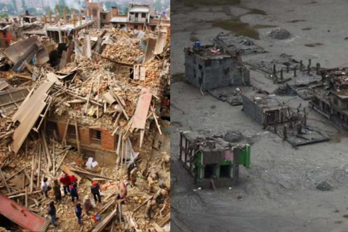
The ground did not shake from a tectonic fault, yet the mountain still came apart. High above the winding gorges of the Langtang National Park, an immense chunk of glaciated rock on the slopes of Langtang Lirung detached with terrifying speed, tumbling nearly four thousand feet into the narrow channel of the Lende Khola. This was not a standard seasonal deluge or a typical monsoon overflow. It was a cryospheric cascade—a high-altitude structural failure of ice, permafrost, and stone that unleashed a sixty-mile wall of slurry, boulders, and pulverized infrastructure down the Trishuli river system.
When the initial wave hit the border settlements and swept south through Rasuwa and Nuwakot, it exposed a grim reality. Communities that survived the historic tremors of 2015 found themselves completely defenseless against a different kind of geological violence. Decades of disaster management policies built around routine river flooding proved entirely obsolete in the face of modern climate-stressed mountain mechanics.
The Blind Spots of Early Warning Infrastructure
Official timelines released in the aftermath of the disaster reveal the terrifying narrowness of modern warning margins. Sensors and cross-border data exchanges flagged the anomaly only moments after the collapse occurred upstream. Hydrologists and local administrators scrambled to push emergency SMS alerts through cellular networks, buying mere minutes for schools like Tribhuvan Trishuli Secondary School to herd students into open spaces. For thousands of others living directly on the floodplains, those minutes evaporated before the phone screens even lit up.
A twenty-minute warning window is useless when a torrent travels down a hyper-steep mountain gradient at highway speeds, carrying millions of tonnes of accumulated sediment and rock debris. Emergency response agencies continue to treat these events as sudden acts of God, preferring the language of unpredictability over institutional accountability. Satellites monitor regional weather patterns, but they do not stare continuously at every destabilized cliff face or weakening permafrost layer across the Hindu Kush Himalaya.
The disaster zones left behind—millions of tonnes of thick grey mud, buried storefronts, and mangled hydropower tunnels—point to systemic planning failures. Infrastructure investments along Himalayan river corridors routinely prioritize short-term economic gains over long-term environmental mapping. Hydro-electric projects and arterial trade routes connecting Nepal to Tibet are repeatedly built in high-risk deposition zones without adequate structural buffers against multi-hazard chain reactions.
Cascading Hazards and the Myth of Isolated Risks
Traditional disaster response frameworks look at threats in tidy silos. Officials plan for earthquakes separately from monsoons, and glacial lake outbursts independently of landslides. Nature refuses to operate by bureaucratic categories.
What occurred in the high Himalayas was a classic compound disaster. A high-altitude ice-rock avalanche triggered an initial kinetic shock, which subsequently formed temporary barrier lakes by choking narrow river gorges. When those unstable debris dams inevitably breached hours or days later, secondary flash floods compounded the original devastation, repeatedly stalling rescue and recovery operations.
Vulnerability mapping compiled by international agencies indicates that over seventy-five percent of the population residing in the affected municipalities lived in areas already marked by above-average multidimensional vulnerability indices. These are not wealthy enclaves capable of absorbing total asset loss. They are agrarian and trading communities whose survival depends on proximity to water and transport routes. When those routes are wiped clean by a wall of gravel, recovery becomes an intergenerational struggle against crushing debt and administrative neglect.
The Cost of Institutional Inertia
Decades of post-disaster postmortems across South Asia follow an identical script. Shock followed by emergency relief, temporary tent settlements, political promises of structural reform, and a quiet return to status-quo development until the next ridge collapses.
Local authorities and international partners are once again debating the merits of better instrumentation and data sharing. Yet, sophisticated sensors mean little if local zoning laws continue to permit dense habitation directly inside historical debris paths. The physical retreat of glaciers across the region—accelerating at double the rate seen at the turn of the century—has left behind thousands of newly formed, highly unstable moraine lakes and unsupported rock walls.
Ignoring these markers does not prevent them from materializing. Every degree of atmospheric warming alters the structural integrity of mountain permafrost, turning the roof of the world into an active construction site of geological hazards. Until disaster management transitions from reactive rescue operations to proactive, high-altitude landscape engineering and mandatory relocation zones, families living downstream will remain tethered to an avoidable lottery of geography and neglect. The mountain has already delivered its next warning, written clearly in the mud and stone of the Trishuli valley.