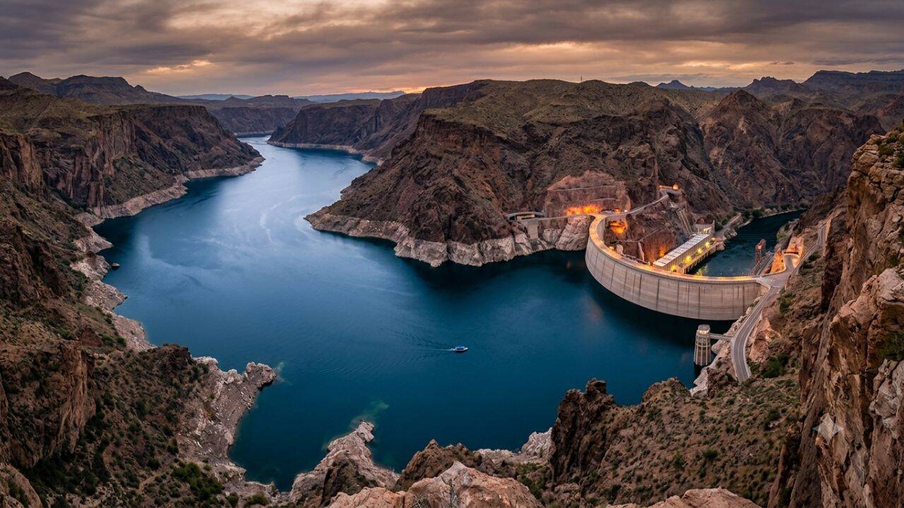
When engineers plugged the mighty Colorado River at the Arizona-Nevada border with millions of tons of concrete, they did not just create the nation's largest water reservoir by capacity. They engineered a vertical abyss. Lake Mead reaches a maximum depth of approximately 532 feet, making it one of the deepest artificial bodies of water in North America. Deep reservoirs across the United States—from Lake Chelan's glacier-carved floor in Washington to Lake Oroville in California—were almost entirely built by flooding ancient river valleys behind colossal concrete and earth-fill dams.
These hydraulic mega-projects transformed North American geography during the twentieth century. They drowned historic towns, swallowed sacred Indigenous sites, and reshaped ecosystems forever. They also provided the hydro-power, flood control, and agricultural storage that allowed the American West and South to boom. If you found value in this post, you might want to check out: this related article.
Understanding these deep man-made lakes requires looking past the ski boats and marina docks to examine the submerged canyons, historic engineering gambits, and ongoing ecological debts beneath the surface.
The Vertical Giants of the American Landscape
Deep artificial lakes are not uniform basins. They are drowned topographies, meaning their floor contours mirror the dramatic cliffs, narrow gorges, and rugged canyons that existed before the floodgates closed. For another angle on this development, see the latest coverage from AFAR.
Lake Chelan (Washington)
While Lake Chelan existed naturally as a fjord-like glacial trough, its depth and surface level were artificially augmented by the construction of the Lake Chelan Dam in 1927. Reaching a staggering maximum depth of 1,486 feet, it ranks as the third-deepest lake in the United States and the deepest reservoir-assisted body of water in the nation. The bottom of the lake sits nearly 400 feet below sea level, plunged into cold, dark isolation by the narrow granite walls of the Cascade Range.
Lake Oroville (California)
Rising above the Feather River in Butte County, Lake Oroville is retained by the Oroville Dam, the tallest dam in the United States at 770 feet. When full, the lake reaches depths of more than 690 feet. It serves as the keystone of the California State Water Project, storing water that travels hundreds of miles to irrigate San Joaquin Valley agriculture and supply southern urban centers.
Lake Mead (Nevada/Arizona)
Formed by Hoover Dam, Lake Mead's maximum depth historically reached 532 feet at the dam face. Its deep-water profile fills the ancient, sheer-walled canyons carved by the Colorado River. Decades of severe drought and heavy extraction have drastically reduced its water volume, revealing drowned rock formations and historical artifacts that had been underwater for nearly a century.
Lake Powell (Utah/Arizona)
Created by impounding the Colorado River behind Glen Canyon Dam in 1963, Lake Powell reaches depths of roughly 560 feet near the dam face. The reservoir flooded Glen Canyon, a labyrinth of red sandstone gorges, ancestral Puebloan ruins, and unique side canyons. It remains a focal point of intense environmental debate regarding water storage efficiency versus natural river restoration.
Fontana Lake (North Carolina)
In the eastern half of the country, deep reservoirs were built largely to power wartime industry. Fontana Lake, formed by the completion of the 480-foot-high Fontana Dam in 1944, reaches maximum depths of roughly 440 feet. Tucked against the Great Smoky Mountains, it was rushed to completion during World War II to supply electrical power to the nearby Aluminum Company of America (ALCOA) plants and the secret nuclear facilities at Oak Ridge.
| Lake Name | Location | Primary River System | Maximum Depth (approx.) | Primary Purpose |
|---|---|---|---|---|
| Lake Chelan | Washington | Chelan River | 1,486 ft | Hydroelectric, Storage |
| Lake Oroville | California | Feather River | 690 ft | Water Supply, Flood Control |
| Lake Powell | Utah / Arizona | Colorado River | 560 ft | Regional Storage, Power |
| Lake Mead | Nevada / Arizona | Colorado River | 532 ft | Storage, Hydropower |
| Fontana Lake | North Carolina | Little Tennessee River | 440 ft | Hydroelectric Power |
The Mechanics of Flooding Ancient Valleys
Why are these lakes so deep? The answer lies in simple economics and topography.
Civil engineers do not dig artificial lakes from scratch. Excavating billions of cubic yards of soil to hold millions of acre-feet of water is financially and physically impossible. Instead, engineers scout for narrow, high-walled river canyons where nature has already done nineties-nine percent of the digging over millions of years.
By constructing a tall barrier at a narrow bottleneck in a valley, water backs up behind the structure. It rises until it fills the contours of the basin. The maximum depth of these reservoirs almost always sits directly behind the upstream face of the dam, where the original riverbed occupied the lowest elevation in the valley corridor.
  Upstream Canyon Wall                              Dam Structure
  ____________________                                  | |
                      \   Submerged Water Profile      | |
                       \~~~~~~~~~~~~~~~~~~~~~~~~~~~~~~~| |
                        \                              | |
                         \                             | |  <-- Deepest Point
                          \____________________________|_|
                                Original Riverbed
This structural reality creates unique hydrologic conditions. Unlike shallow, broad lakes that warm quickly and mix thoroughly from top to bottom through wind action, deep reservoirs stratify into distinct thermal layers.
The top layer, or epilimnion, is warmed by sunlight and oxygenated by surface breezes. Beneath it lies the thermocline, a zone of rapid temperature drop. At the bottom sits the hypolimnion, a cold, high-pressure, low-oxygen vault that remains isolated for much of the year.
What Lies Beneath the Water
The creation of these massive reservoirs was not without conflict. Flooding thousands of acres of populated or culturally significant land required radical eminent domain actions and the forced relocation of entire communities.
Before Lake Mead filled, the town of St. Thomas, Nevada, was a thriving agricultural settlement established by Mormon pioneers in 1865. In 1938, as water backed up behind Hoover Dam, the town's last resident rowed away from his home. For decades, St. Thomas sat submerged beneath more than 60 feet of water. Recent megadroughts have lowered Lake Mead so drastically that the concrete foundations, stone chimneys, and tree stumps of St. Thomas sit high and dry once again, eerie monuments to human engineering choices.
In North Carolina, the construction of Fontana Dam forced the relocation of more than 600 families and inundated the towns of Proctor and Fontana. The project cut off road access to a vast portion of the Great Smoky Mountains National Park, creating a decades-long dispute over access to ancestral cemeteries buried deep in the forest behind the lake.
Beyond human settlements, these deep waters drowned uncounted archaeological sites. Rock art panels, ancient campsites, and historical structures were permanently submerged. While some salvage archaeology was conducted prior to inundation—such as the rushed efforts in Glen Canyon during the late 1950s—vast amounts of human history were simply swallowed by the rising tides.
The Ecological Toll of Submerged Valleys
Lakes created by damming steep river canyons do not behave like natural lakes. Natural lakes evolve over millennia, developing stable shorelines, gradual littoral zones, and complex organic balances. Reservoir lakes are dynamic, heavily controlled industrial assets subjected to wild water level fluctuations.
When water levels draw down quickly to meet summer agricultural demand or municipal consumption, miles of mudflats and steep, barren banks are exposed. This zone—the drawdown zone—is structurally hostile to vegetation and fish spawning. Native plants cannot establish roots where water levels jump tens or hundreds of feet in a single season.
Furthermore, deep dams alter the thermal regime of the rivers downstream. Water pulled from the bottom of a deep reservoir is icy cold and stripped of sediment. When released through hydroelectric turbines, this clear, cold water starves the downstream river of the silt necessary to build sandbars, while fundamentally altering the water temperatures that native fish species require to spawn.
Sedimentation remains an relentless, ticking clock for every deep reservoir in America. Rivers naturally transport sand, mud, and gravel down toward the sea. When a river meets the quiet water of a deep reservoir, its velocity drops to zero. The sediment drops to the bottom.
Year after year, decade after decade, deep reservoirs are steadily filling with mud from the bottom up. In time, every dammed valley reservoir face a eventual choice: expensive dredging operations, structural modification, or eventual decommissioning as the basin silt fills completely.
The Future of Deep Storage
Deep reservoirs remain essential lifelines for power generation, crop production, and municipal drinking water across the country. Yet, they face unprecedented pressures from changing climate patterns, shifting rainfall distributions, and relentless structural aging.
As water levels drop to historic lows in some regions and intense storm events threaten spillway infrastructure in others, managing these drowned canyons has become a dangerous balancing act. These engineering marvels stand as stark reminders of an era when humanity believed it could permanently bend North America's river systems to its will—only to discover that the rivers, and the canyons they carved, always demand a long-term accounting.